UAS development from 2014- fantastic new uses and forecasts of cutting-edge designs to 2046—FAA Challenge?
The future of the UAS burgeoning drone industry is only limited by entrepreneurial innovation infused into this emerging aerial technology. Below are two recent articles describing some of the innovative use of UASs that this new form of flight has unleashed:
- autonomous hybrid eVTOL for unique middle-mile niche in logistics- MightyFly

- the need for an association to represent public safety uncrewed aerial systems (UAS), counter-UAS and advanced air mobility (AAM), DRONERESPONDERS,


The December 16,1903 for UAS[1] was first FAA‑authorized commercial UAS flight in the United States occurred on June 21, 2014, in Prudhoe Bay, Alaska, conducted by BP using an AeroVironment Puma AE for pipeline and infrastructure inspection. The line up of the new utilization of this genius of aeronautical engineering is an impressive American Enterprise.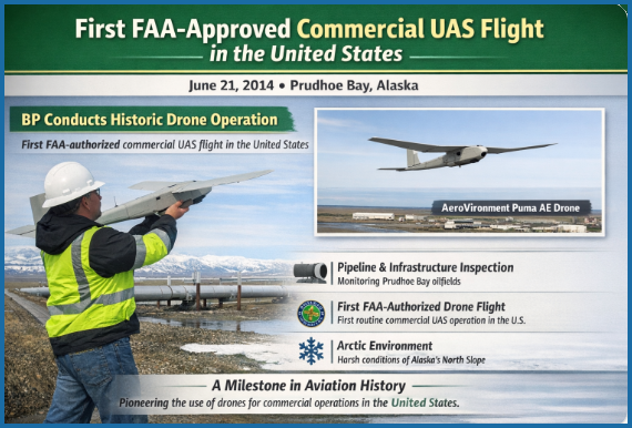
If Samuel F.B. Morse witnessed this remarkable transformation in commercial aviation, he might exclaim “WHAT HATH GOD WROUGHT,” seeing it as something so extraordinary that only divine providence could account for it.
The below list (11 general fields and 38 specific lines of business [AI CoPilot research]) has been generated in less than a dozen years —
- Remote Sensing, Mapping & Inspection
-
- Infrastructure inspection: pipelines, powerlines, substations, bridges, rail corridors.
- Surveying & mapping: photogrammetry, LiDAR, terrain modeling, construction progress.
- Environmental monitoring: wetlands, wildlife, erosion, forestry, emissions.
- Agricultural analytics: crop health (NDVI), soil moisture, plant stress, yield prediction.
-
- Logistics & Delivery
-
- Small‑parcel delivery: medical samples, consumer goods, spare parts.
- Middle‑mile logistics: depot‑to‑depot transfers, warehouse‑to‑hub movement.
- Critical medical transport: blood, vaccines, lab specimens, emergency supplies.
- Ship‑to‑shore logistics: maritime resupply, offshore platform deliveries.
-
- Urban & Regional Mobility (AAM / eVTOL‑related UAS)
-
- Autonomous cargo eVTOL operations: heavy‑lift unmanned cargo aircraft.
- Feeder‑route logistics: regional unmanned aircraft connecting rural/remote communities.
- Autonomous air taxi precursor operations: pilotless testbeds for future passenger AAM.
-
- Imaging, Media & Creative Industries
-
- Cinematography & broadcast: film, live sports, news gathering.
- Real estate imaging: property visualization, 3D tours.
- Event coverage: concerts, festivals, public events.
-
- Public Safety & Emergency Response
-
- Search and rescue: thermal imaging, missing‑person location.
- Fire response: hotspot detection, fireline mapping, smoke plume modeling.
- Law enforcement support: situational awareness, accident reconstruction.
- Disaster assessment: floods, hurricanes, earthquakes, damage mapping.
-
- Agriculture & Resource Management
-
- Precision spraying: pesticides, herbicides, fertilizers.
- Seeding & planting: reforestation, cover crops, ecological restoration.
- Livestock monitoring: herd tracking, fence line inspection.
- Aquaculture monitoring: fish stock assessment, water quality sensing.
-
- Industrial Operations
-
- Mining & quarrying: volumetrics, blast planning, stockpile measurement.
- Oil & gas operations: flare stack inspection, leak detection, offshore monitoring.
- Utilities operations: solar farm inspection, wind turbine blade analysis.
-
- Security & Monitoring
-
- Perimeter security: industrial sites, ports, airports, prisons.
- Event security: crowd monitoring, traffic flow analysis.
- Border and coastline monitoring: persistent surveillance, anomaly detection.
-
- Communications & Networking
-
- Temporary airborne cell towers: disaster recovery, rural connectivity.
- Mesh networking nodes: pop‑up communications for events or emergencies.
- High‑altitude pseudo‑satellites (HAPS): long‑endurance telecom platforms.
-
- Scientific, Research & Environmental Missions
-
- Atmospheric sampling: pollution, greenhouse gases, microclimate studies.
- Wildlife research: migration tracking, population surveys.
- Oceanographic support: coastal mapping, algal bloom detection.
-
- Specialized Niche Markets
-
- Insurance claims assessment: post‑loss documentation.
- Archaeology & cultural heritage: site mapping, artifact protection.
- Agricultural insurance & compliance: acreage verification, crop damage assessment.
- Entertainment & light shows: coordinated drone swarms.
-
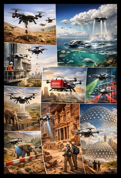
AI can explore future possible ventures and here is Copilot’s prescience demonstrated (?DISAGREE?); this menu has 8 different sectors and 24 different separate applications–
- Environmental & Planetary Stewardship
- Autonomous micro‑reforestation swarms
Seed‑planting drones that coordinate underground moisture mapping, species selection, and long‑term growth monitoring. - Atmospheric “micro‑labs”
Persistent UAS that sample air chemistry at thousands of points to detect methane leaks, volcanic precursors, or wildfire ignition signatures. - Ocean–air interface drones
Hybrid UAS that skim the surface to track microplastics, algae blooms, or illegal fishing.
- Autonomous micro‑reforestation swarms
- Urban Infrastructure Roles
- Dynamic “digital twin” maintainers
Drones that continuously update 3D models of cities, enabling real‑time structural health monitoring of bridges, tunnels, and skyscrapers. - Autonomous curb‑to‑roof logistics
Not just package delivery—micro‑UAS that move tools, documents, or medical samples between floors of a building or across a campus. - Emergency corridor creation
Swarms that coordinate to clear airspace, map hazards, and guide responders through smoke, debris, or collapsed structures.
- Dynamic “digital twin” maintainers
- Cognitive & Data‑Centric Uses
- Edge‑AI “thinking drones”
UAS that perform onboard analytics for agriculture, construction, or disaster zones without needing cloud connectivity. - Mobile cybersecurity sentinels
Drones that patrol wireless environments, detecting rogue access points or spoofing attempts in large facilities. - Autonomous data‑mules
UAS that physically transport encrypted data between isolated networks or remote research stations.
- Edge‑AI “thinking drones”
- Physical Manipulation & Micro‑Robotics
- Precision micro‑construction
Drones that 3D‑print or assemble components in hard‑to‑reach places—think façade repairs or antenna installation. - Aerial “tugboats”
Coordinated UAS that reposition large objects (solar panels, scaffolding, antennas) using distributed lift. - In‑flight refueling for small robots
Drones that recharge other drones mid‑air using wireless power transfer.
- Precision micro‑construction
- Biological & Medical Applications
- Airborne bio‑sensing for public health
Drones that detect airborne pathogens in crowded areas or monitor wastewater aerosols near treatment plants. - Precision pollination ecosystems
UAS that supplement declining pollinator populations with species‑specific pollen delivery. - Autonomous organ‑transport corridors
High‑priority UAS lanes for rapid, temperature‑controlled organ or blood transport.
- Airborne bio‑sensing for public health
- Cultural, Creative & Social Uses
- Dynamic aerial architecture
Swarms forming temporary structures—canopies, light sculptures, or acoustic shells for concerts. - Personal “aerial companions”
Small UAS that act as mobile camera crews, translators, or accessibility assistants for people with disabilities. - Heritage preservation mapping
Drones that capture micro‑detail of archaeological sites before erosion or conflict destroys them.
- Dynamic aerial architecture
- Strategic & Global Systems
- Climate‑intervention micro‑platforms
UAS that release reflective aerosols or cloud‑seeding agents in highly controlled, localized ways. - Autonomous border‑to‑border wildlife corridors
Drones that guide animal migrations away from roads, farms, or conflict zones. - Global “sensor mesh” for Earth observation
Persistent UAS networks filling gaps between satellites and ground sensors.
- Climate‑intervention micro‑platforms
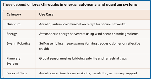
- Entirely Speculative but Technically Plausible
- Aerial quantum‑communication relays
Drones acting as mobile entanglement nodes for secure communications. - Atmospheric energy harvesters
UAS that tap into wind shear or static charge gradients to recharge themselves. - Self‑assembling mega‑swarms
Thousands of drones forming large, temporary structures—communication arrays, emergency shelters, or even reflective shields.
- Aerial quantum‑communication relays
So what is the prognosis for market entry:
⇒Near-Term (2026–2032): Emerging Capabilities
| Category | Use Case |
| Environment | Seed-planting drones for reforestation and wildfire recovery |
| Urban Infrastructure | Micro-construction drones for façade repairs and antenna installation |
| Medical | Organ transport drones with temperature-controlled payloads |
| Security | Cybersecurity sentinels scanning for rogue access points |
| Cultural | Archaeological mapping drones preserving endangered sites |
⇒Mid-Term (2033–2045): Integrated Systems
| Category | Use Case |
| Climate | Micro-platforms for localized aerosol release (geoengineering) |
| Wildlife | Autonomous migration guides for endangered species |
| Urban Logistics | Curb-to-roof autonomous delivery and inter-floor transport |
| Data | Edge-AI drones performing analytics without cloud dependency |
| Creative | Aerial architecture for concerts, shelters, or temporary structures |
⇒Far-Future (2046+): Speculative & Transformative
![]()
MightyFly Is Working on a Cargo Drone that Can Fly 1,000-Miles and Carry 500 Pounds
BY Zacc Dukowitz
Cargo drone company MightyFly just raised $10 million to build an autonomous hybrid eVTOL that will fly 1,000 miles carrying 500 pounds. Those are big numbers. Most delivery drones are designed for “last mile” delivery—just a few miles at most, and with only a few pounds. But MightyFly’s drones aren’t made to carry burritos. They’re made for an entirely different category of delivery: regional cargo, competing with trucks and crewed aircraft.
MightyFly on CNN’s Adaptation Nation of The Whole Story With Anderson Cooper
What MightyFly Is Building
MightyFly is developing a long-range autonomous cargo drone that aims for an ambitious 1,000-mile range with 500-pound capacity.
The aircraft uses electric propulsion, with an onboard combustion engine acting as a generator to recharge the batteries in flight.
It also promises a small takeoff and landing footprint.
For the MIGHTYFLY CENTO—the best reference point for the new drone, since its specs aren’t public yet—the footprint is the size of two standard parking spaces.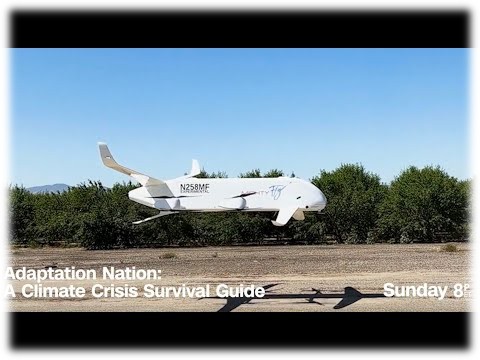
https://www.youtube.com/watch?v=iN1ds5mPatoThe MightyFly Cento
Specific specs for the new 1,000-mile, 500-pound beast are under wraps for now.
But the MightyFly Cento, which is already out, offers a preview of the new, unnamed cargo drone’s potential.
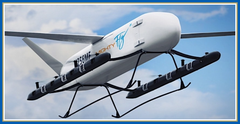 The MightyFly Cento | Credit: MightyFly
MightyFly Cento Specs & Features
- Battery life. About 4 hours of total flight time
- Flight range. Up to 600 miles (about 965–966 km) per mission.
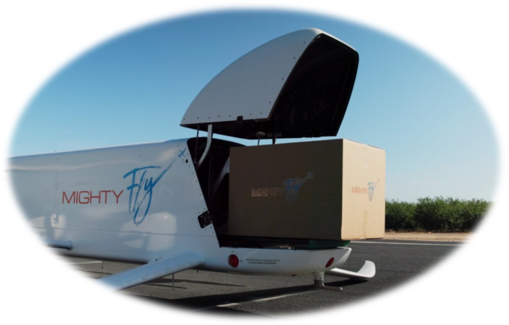
- Payload capacity. 100 lb (45 kg) maximum payload, with enough volume to carry over 200 small parcels in its internal cargo bay.
- Top speed. Up to 150 mph (240 km/h) cruise, significantly faster than road-based vans over similar distances.
- eVTOL configuration. Lift‑and‑cruise eVTOL layout with eight fixed vertical lift propellers for takeoff and landing and a single pusher propeller for efficient forward flight.
Autonomy Highlights
MightyFly’s drones run fully autonomous missions, which are supervised remotely by operators managing fleets from a central hub. And their autonomy extends beyond the flying–the drones can also load and unload cargo on their own.
Key autonomy tech includes:
- Onboard sensors with ADS-B and UTM for collision avoidance and airspace visibility.
- Multi-stop sequencing across customers in one flight.
- ALMS* for automated cargo handling, securing, and center-of-gravity checks.

*Note: ALMS stands for Autonomous Load Mastering System, a patented technology developed by MightyFly for their Cento cargo drone.
MightyFly’s Role in Logistics
MightyFly’s cargo drones target a unique middle-mile niche in logistics.
These platforms can haul 100–500 pounds over 600–1,000 miles with multiple stops per flight, all without needing runways or dedicated landing pads.
These numbers position these drones solidly in the middle between short-range drone delivery—think Zipline or Wing—and long-haul, fixed-route drone delivery for industrial use cases—say, delivering supplies to remote offshore oil rigs.
Credit: MightyFly
In the U.S., goods often travel 300–800 miles by truck due to air cargo’s cost and infrastructure demands. MightyFly aims to disrupt that with pilotless, autonomous efficiency on repeatable routes.
The primary use cases for MightyFly’s drones are:
- Warehouse-to-warehouse transfers
- Medical supply runs between cities
- Rural logistics
- Industrial resupply
Progress Toward Launching
MightyFly has already built and flown several full-scale prototypes as it works toward commercial deployment.
According to the company, three aircraft have collectively completed more than 400 autonomous test flights.
Those flights are part of a broader effort to demonstrate reliability and autonomy under real operating conditions—an essential step before any large-scale cargo service can launch.
On the regulatory side, MIGHTYFLY HAS SECURED FAA SPECIAL AIRWORTHINESS CERTIFICATES AND CERTIFICATES OF AUTHORIZATION (COAS) that allow it to conduct advanced testing, including long-range beyond visual line of sight (BVLOS) operations under approved conditions.
The next major milestone will be pursuing Part 135 certification, which would let the company operate as an air carrier for commercial cargo delivery.
MightyFly’s big-drone concept points toward a future where regional cargo moves autonomously between cities, warehouses, and industrial hubs—quietly, predictably, and without a pilot onboard.
But the REAL TEST won’t be whether the new drone can hit 1,000 miles and carry 500 pounds, as impressive as that would be.
It will be whether these drones can actually operate reliably on routine flights, over and over.
Reliability is what has made Zipline stand out—they’ve flown over 125 million autonomous miles—and that kind of reliability through repetition will be the target for MightyFly if it wants to make this work.

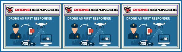
DRONERESPONDERS creates AAM and UTM working group with FAA and NASA participation
March 13, 2026Kylie Bielby UAS traffic management news

DRONERESPONDERS, a non-profit programme in the United States advocating for public safety uncrewed aerial systems (UAS), counter-UAS and advanced air mobility (AAM), has created a national AAM Working Group.
The group is designed to assist public safety agencies understand, prepare for and help shape the evolving AAM and unmanned traffic management (UTM) landscape across the US. NASA and the Federal Aviation Administration (FAA) will participate in the initiative.
“The AAM Working Group will provide public safety organisations with timely insight into emerging airspace systems, UTM architectures and advanced aviation technologies,” DRONERESPONDERS said. “Its mission is to ensure that future airspace designs and operational frameworks support access to critical public safety UAS missions while enabling the safe and efficient integration of advanced air mobility into the national airspace system.”
The working group will convene monthly meetings, bringing together representatives from NASA, the FAA, DRONERESPONDERS, public safety agencies and private-sector partners with a view to streamlining communication, sharing developments, and aligning priorities as advanced aviation technologies continue to evolve.
“Public safety must have a seat at the table as advanced air mobility and UTM systems evolve,” said Jason L. Day, Deputy Director of Training at DRONERESPONDERS. “This working group ensures that first responders remain informed, engaged and prepared to operate safely and effectively in the next generation of the national airspace.”
DRONERESPONDERS has also created the Oklahoma Public Safety Coordination Group (OKGRU) this week, expanding its national network of state-level government and public safety uncrewed aviation initiatives. The new state-level working group will bring together public safety professionals, government partners, and industry stakeholders to promote the safe and effective use of UAS across Oklahoma.
For more information
Image: DRONERESPONDERS
[1] You decide whether the original nomenclature or #47 version is what this means!!!